June 19, 2014, 10:04 am
Several years ago QuakeFinder realized that we just would not get enough earthquakes in California to characterize the electromagnetic signals associated with earthquakes in a reasonable time. We did a study to see which countries had the most earthquakes greater than M5 per year on average. Taiwan was found to have about 15x the number of M5+ quakes than California, so we contacted a colleague (Dr. Tiger Liu) at the National Central University (NCU) in Taiwan. So far, this collaboration has resulted in 5 trips to Taiwan and 15 donated instruments. Together with Dr. Liu and Ian Chen, his assistant, we found good locations mostly along the eastern coastline, close to the subduction fault that borders Taiwan.

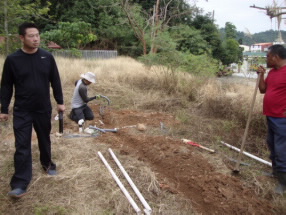
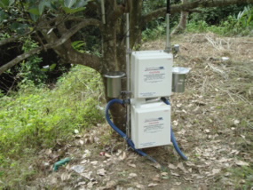
In May of this year, QuakeFinder technicians Bob and Rey Camins traveled to Taiwan, installed the last 4 instruments, and upgraded the existing 11 instruments to the latest configuration, completing the network. Our colleagues were especially helpful in getting this network installed and running. The installation process involved 12-hour work days, mosquitoes, really large spiders, and occasional snakes. During this trip, heavy rain and landslides were added to the challenges, but the team hung in there and finished the job on time. Many thanks go to the entire team for all their cooperation and hard work.

April 17, 2014, 8:39 pm

At 5:12 AM on April 18, 1906, the ground shook like it had never done before in San Francisco. An estimated Magnitude 7.8 earthquake broke the city, and started numerous fires that decimated what was left of many structures. Over 3,000 people died. This major earthquake ruptured 296 miles (477 kilometers) of the San Andreas Fault from San Juan Bautista to Cape Mendocino. No warning was available then. Even today, 108 years later, there is no accepted warning system for such a quake. In 1906, horses were reported to be agitated in the barns near the Presidio prior to the quake. What were they sensing? We think that they may have sensed ultra low frequency magnetic waves or static electricity from ionized air around them. Today we have instrumented much of the San Andreas and other major faults in California with sensitive magnetometers and air ionization sensors to see if these phenomena occur regularly before large quakes. We are actively collecting a valuable “baseline” of electromagnetic signatures for these faults. The hope is that future major quakes repeat the same two week sequence of magnetic pulses and air conductivity changes observed by QuakeFinder instruments that preceded the M5.4 Alum Rock, CA and M6.2 Tacna, Peru quakes in 2007 and 2010 respectively.
April 3, 2014, 8:32 am
The massive M8.2 quake near Iquique, Chile on April 1 reminds us that the northern area of Chile near the Peru border had been long overdue for a large earthquake.
QuakeFinder has been concerned about this area since 2010 when we installed 4 sites on the Peru side of the border. In January 2014 we installed a new site 40 miles (approximately 64 kilometers) south of Iquique, working with our partners at Pontificia Universidad Catolica de Chile in Santiago, Universidad de Concepción, Universidad Andrés Bello (UNAB), and Center of the Desert in Iquique. The earthquake happened to the NW of Iquique about 90 miles (144 kilometers) from that site. Our range of detection is around 10 miles (16 kilometers), but the M7.8 was 27 miles (44 km) from our site and may show that the aftershocks are migrating closer to our lone site there. Our small network in Chile needs to be expanded to cover more critical areas, and we are continuing to look for partners to assist in this effort. With this site near Iquique, we are excited to be in the right area and continuing analysis of these quakes will advance the state of the art of earthquake forecasting. Get involved. Contact us at
supportQF@quakefinder.com
March 13, 2014, 9:36 am
QuakeFinder started a new magnetometer network in Chile in January. Why Chile?
There are lots of earthquakes in Chile!
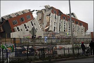
Chile had the world’s largest recorded earthquake in modern history—a M9.5 near Valpariso in May of 1960 (greater than Sumatra, Japan, and Haiti)and it generated a 38 ft tsunami. More recently, Chile had another M8.8 in Feb 2010, between Santiago and Conception, with some of the damage shown in the picture below.
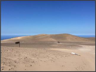
We found some wonderful collaborators at the Catholic University in Santiago (PUC-C), at the University of Conception, a marine research center (UNAB), and a desert research center (Patache Sur). We delivered 4 instruments to Chile and installed them at sites called Tigo (Conception), El Tabo (west of Santiago), UNAB (also west of Santiago), and Iquique (in the Atacama desert). The site appearances were quite different, from the Mars-looking Atacama desert (below)
…to lush forest area near Conception.
We received great cooperation from the 4 different groups at the 4 sites, and we hope this will be the start of a long and scientifically beneficial relationship in Chile.
 In May of this year, QuakeFinder technicians Bob and Rey Camins traveled to Taiwan, installed the last 4 instruments, and upgraded the existing 11 instruments to the latest configuration, completing the network. Our colleagues were especially helpful in getting this network installed and running. The installation process involved 12-hour work days, mosquitoes, really large spiders, and occasional snakes. During this trip, heavy rain and landslides were added to the challenges, but the team hung in there and finished the job on time. Many thanks go to the entire team for all their cooperation and hard work.

 In May of this year, QuakeFinder technicians Bob and Rey Camins traveled to Taiwan, installed the last 4 instruments, and upgraded the existing 11 instruments to the latest configuration, completing the network. Our colleagues were especially helpful in getting this network installed and running. The installation process involved 12-hour work days, mosquitoes, really large spiders, and occasional snakes. During this trip, heavy rain and landslides were added to the challenges, but the team hung in there and finished the job on time. Many thanks go to the entire team for all their cooperation and hard work.


