32 Day Pulse Plots
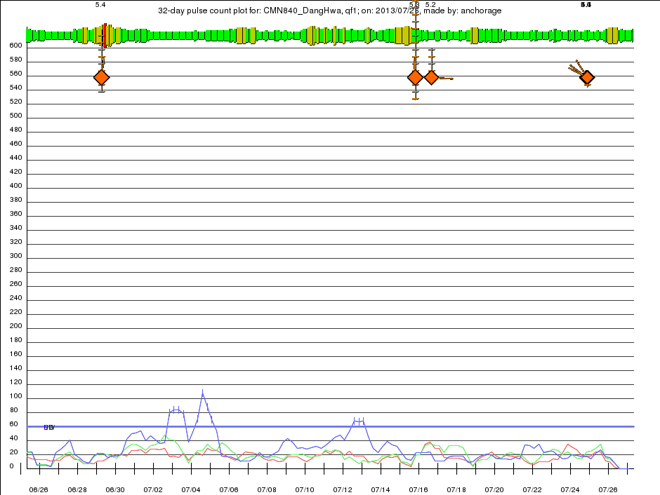
The 32 Day Pulse Plot is created after the Daily Pulse Plot, and mesures the rate of daily pulses. It shows pulse counts of geomagnetic pulses that QuakeFinder has found from the selected site in a 32 day period. There are three traces, red, green, and blue that correspond to the North-South, East-West, and Vertical components of the geomagnetic signal respectively. Each trace shows the count of pulses in a 24-hour period, and there are four points in each day, meaning the 24-hour periods overlap each other by 75% and 128 counts are shown on every plot. When the geomagnetic signal trace pulse counts exceeds the count limit at any time, the QuakeFinder team is notified, triggering further analysis. These limits are constantly being refined, and may change monthly, daily, or hardly at all, depending on how the site behaves. An example from our Dang Hwa site in Taiwan is shown here:
 Layers of the 32 Day Pulse Plot are:
Kp Planetary Activity

Kp Planetary Activity
- Published by NOAA (The National Oceanic and Atmospheric Administration) as a global value every hour. The level of activity in the Earth’s geomagnetic field is represented by an indicator in the range of 1-3 (Green), 4-6 (Yellow) and 6-9 (Red). The highest levels of activity can generate large signals that are seen across the QuakeFinder network. The Kp indicators are spaced one hour apart and are proportionally taller for higher levels of activity. These are the same as the KP markers on the Daily Pulse Plot, only there are 32x as many on the plot.
- This is a compound Marker that is overlaid onto the geophone trace. In the example above, several m5+ plus earthquakes are shown. The magnitude is written at the top of the plot, and in this example there are two reports in the ANSS catalog, and therefore two markers are drawn here almost on top of each other. The diamond gets larger for larger quakes, but range, depths, and compass bearing are also given by the mark. Range to an earthquake is depicted by the ladder rungs rising above the diamond, in this case the quake is 44 Km from the site. Each ladder rungs denotes 10 Km. Depth is depicted by the down ladder rungs, each also 10 Km spaced. Compass bearing is shown by the lines angled down to the left, in this case the earthquake is to the Southwest of the site. Sometimes multiple quakes occur in rapid succession, and on the scale of 32 days, their markers are so close together that they overwrite each other. This is normal behavior.
- These are the red, green, and blue horizontal lines that indicate the triggering pulse counts that will alert the QuakeFinder team.
- These are the red, green, and blue signals that sometimes cross the Pulse Count Limits. These events are know as “Limit Excursions” and they are reported into a database and to the QuakeFinder team. Vertical ticks are added to the traces to indicate that indeed the database entries were made.
